
Geological Reports
Geological reports are comprehensive documents that provide detailed information about the geological characteristics, formations, and processes of a particular area or site. These reports are typically prepared by geologists and other experts in the field and serve various purposes, including land development, mineral exploration, environmental assessment, and hazard mitigation. Here are some key components typically found in geological reports:
1. Introduction: This section provides an overview of the report’s purpose, scope, and objectives. It may also include background information on the study area and any previous geological work conducted.
2. Geological Setting: Describes the geological context of the study area, including the regional geology, rock types, structures (such as faults and folds), and geological history. This section helps establish the broader geological framework within which the site is situated.
3. Field Methods and Data Collection: Details the methods used to collect geological data, including field mapping, rock sampling, geophysical surveys, and laboratory analyses. It discusses the techniques employed to characterize the geological features and formations present in the area.
4. Geological Maps and Cross-Sections: Presents maps and cross-sections depicting the geological features, rock units, structures, and other relevant information observed during fieldwork. These visual representations help readers visualize the subsurface geology and understand the spatial relationships between different geological elements.
5. Geological Interpretation: Provides interpretations and analyses of the collected data, including the geological history, formation processes, structural evolution, and potential geological hazards or resources. This section synthesizes the observed geological features into a coherent understanding of the site’s geological evolution.
6. Geological Hazards and Risks: Assesses potential geological hazards and risks associated with the site, such as landslides, earthquakes, sinkholes, or groundwater contamination. It may include recommendations for mitigating these risks and ensuring safe development or land use practices.
7. Conclusion and Recommendations: Summarizes the main findings of the report and offers recommendations for further studies, land management strategies, engineering design considerations, or environmental protection measures based on the geological assessments.
Geological reports are essential tools for decision-making in various sectors, including construction, mining, infrastructure development, and environmental management. They provide valuable insights into the geological characteristics of an area, helping stakeholders make informed decisions and mitigate geological risks effectively.
To DOWNLOAD click on specific file.
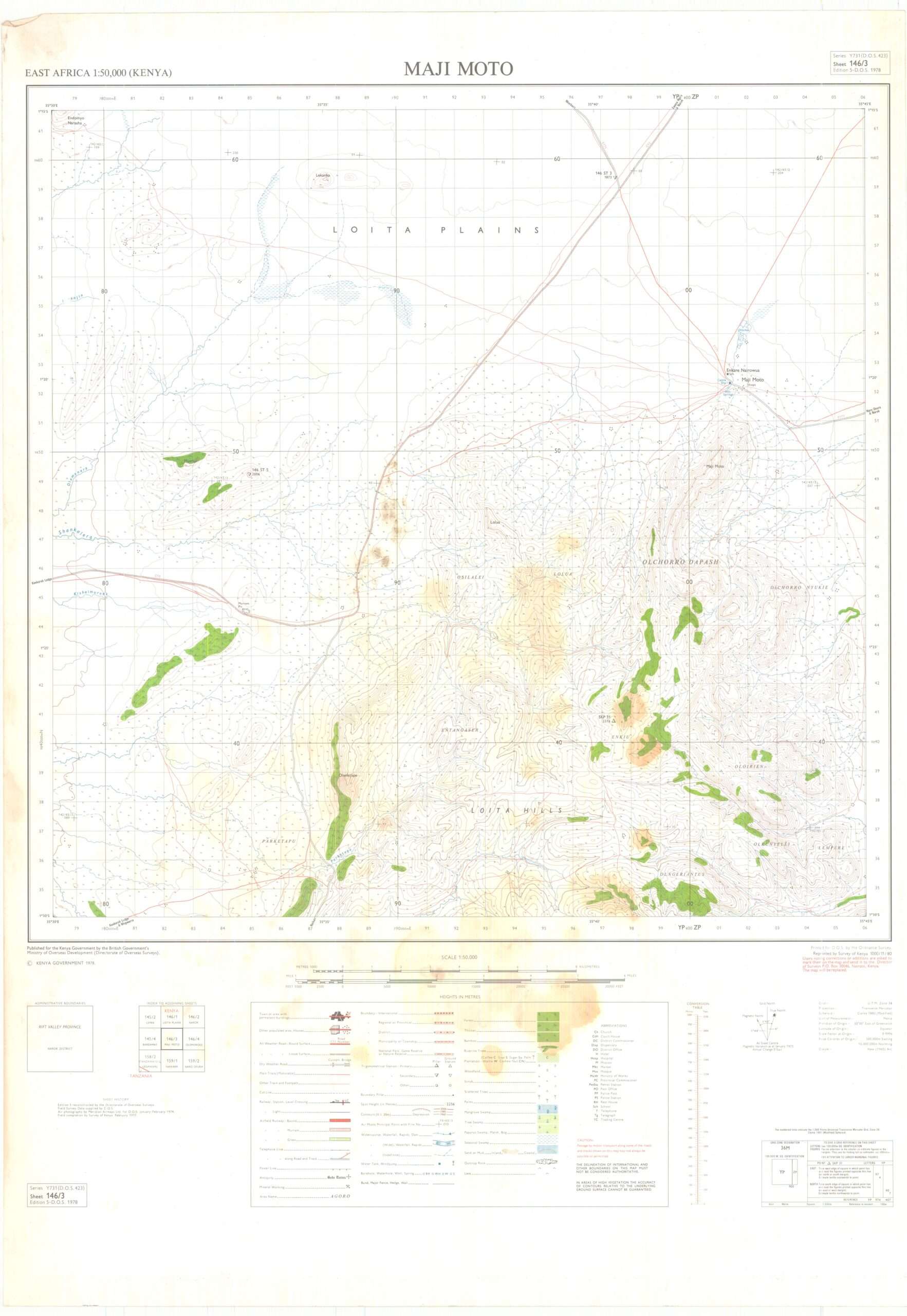
Topographical Maps
Topographical maps, also known as topo maps or contour maps, are detailed representations of the Earth’s surface, showcasing various features such as elevation, terrain, and landmarks. These maps use contour lines to depict changes in elevation, helping users visualize the three-dimensional landscape on a two-dimensional surface.
Key components of a topographical map include:
1. Contour Lines: These lines connect points of equal elevation, indicating changes in terrain. Closer contour lines represent steeper slopes, while widely spaced lines signify flatter areas.
2. Elevation: Topo maps often include numerical values indicating the elevation of certain points above sea level. This information helps users understand the height differences across the landscape.
3. Scale: Topographical maps come in different scales, representing varying levels of detail. A larger scale provides more detailed information over a smaller area, while a smaller scale covers a larger area with less detail.
4. Legend: The legend or key on a topo map explains the symbols and colors used to represent features such as roads, rivers, forests, and man-made structures. It helps users interpret the map accurately.
5. Grid Coordinates: Grid lines and coordinates are often included to help users pinpoint locations on the map with precision. These grids are typically based on latitude and longitude or a local coordinate system.
6. Orientation: Topo maps are oriented with north at the top, allowing users to maintain their sense of direction while navigating the terrain.
7. Relief Features: In addition to contour lines, relief features such as hills, valleys, ridges, and cliffs are depicted to provide a comprehensive understanding of the landscape’s topography.
Topographical maps are invaluable tools for various outdoor activities, including hiking, camping, surveying, and urban planning. They offer detailed insights into the terrain, enabling users to plan routes, assess elevation changes, and navigate safely across diverse landscapes.
To DOWNLOAD click on specific file.
Disclaimer: If you have the rights to any of these apps or reports and don’t want them published here, you can Contact Us.
Also, if you have other apps or reports that you would like published here you can still Contact Us.

